Your guide to navigating the streets of Cape Coral
Have you ever been driving down the road in Cape Coral and suddenly the road ends and your looking at a canal?
But how could that be!! You haven’t even gotten to the house number yet!
On the flip side of that. Have you ever given someone a street address and they can pin point the location on the map in under 5 seconds? Cape Coral roads were designed for just that, to pinpoint a location based on the address. The system for our roads are based on a grid, however, that grid can get pretty frustrating when the road is cut off by a canal and you have to go all they way around to get where your going.
GPS Navigation is definitely your friend for navigating the streets of Cape Coral when you are first learning your way around, but once you learn the lay of the land, you’ll be pinpointing locations in no time! Ok, just kidding, I still use GPS! But my former team leader knew the grid system and could pinpoint out a location on the map. It was admirable.
You will notice most all the roads are numbers, with our main roads having names . The exception here is the Yacht club area and gated communities and a handful of neighborhoods.
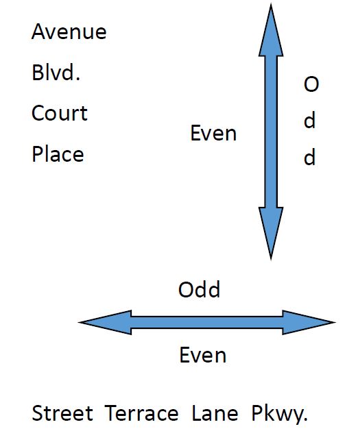
Here’s where it gets fun! Use this little cheat sheet to follow along with.
As you know, Cape Coral is divided into 4 quadrants, Southwest (SW), Southeast (SE), Northwest (NW) and Northeast (NE). The north Cape is divided from the south by Hancock Bridge Road, Pine Island Road and Embers Parkway. East and west are divided by Santa Barbara Boulevard. This is the first step when looking at an address. Is it SW 47th Ter you are looking for? Or NE 18th Ave?
The main arterial, unobstructed roads that run west to east are Parkways. For example; Cape Coral Parkway, Veterans Parkway, Diplomat Parkway.
The main arterial roads that run North to South are Boulevards. For example; Chiquita Blvd, Skyline Blvd, Santa Barbara Blvd.
Avenues, Place and Court run north to south.
Street, Terrace, and Lane runs West to East.
All roads are numbered in ascending order from the intersections of parkways and boulevards.
If you Look at the roads on either side of Santa Barbara Blvd, the dividing line between west and east, you will notice that all of the Avenue, Place and Court roads (North to south roads) all start at 1. The numbers go up the further east or west you go.
Same applies for the roads that divide the north and south.
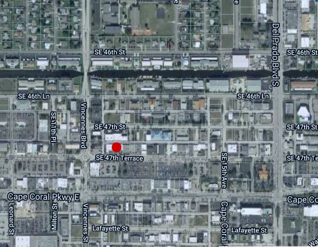
With all this new found information, can you pinpoint 1219 SE 47th Terrace?